Publications
Throughout his career, Robert has authored more than 20 research papers on topics related to harmful algal blooms, riparian area functioning and restoration. Below are details on a few of his papers. A full list of publications by Robert K. Hall can be accessed through ResearchGate here.
Regional Sustainable Environmental Science (RESES): Floating Vegetated Islands: Using Traditional Ecological Knowledge (TEK) for Development of Leading Indicators of Ecosystem Function for Best Management Practice (BMP) Effectiveness, Water Quality Standards, Biological Criteria, and Control of Harmful Algal Blooms (HABs)
Eric Steven Hall, John Lin & Robert K. Hall
September 2020
Report number: EPA/600/R-20/298 - Affiliation: United States Environmental Protection Agency
Project: Training and Technical Assistance to Native American Tribes: DW-14-92439901-A
Abstract
The research documented in this report was conducted by the US EPA Office of Research and Development, US EPA Region 9, the United South and Eastern Tribes (USET), the Colorado River Indian Tribes (CRIT), and the Chemehuevi Indian Tribe (CIT). The research project was designed to assess if (artificial) floating islands, containing different native plant species, could be used to reduce excess nutrients in tribal waterbodies and reduce the ecological and human exposure risk to harmful toxins (Harmful Algal Blooms/Cyanobacteria) and associated pollutants in riparian-wetland areas.
Ecological risk based assessment used to restore riparian physical functions to a fresh water Creek
Robert K. Hall, John Lin, Brian A. Schumacher, Kerry-Ann Charles & Daniel T. Heggem
May 2018
Journal of Environmental Management volume 221, pages 63-75
Abstract
The purpose of this study was to determine if an interdisciplinary team using a qualitative proper functioning condition (PFC) assessment protocol could identify and reverse significant detrimental ecological alterations which occurred within Gertie's Creek watershed, Ontario, Canada. At potential, Gertie's Creek supported a woody debris glacial outwash fine gravel substrate fish spawning habitat. The anthropogenic activities on Georgina Island caused a denuded anadromous fish population since the early-to mid-1990's in the Gertie's Creek watershed. The PFC assessment indicated that anthropogenic activities on Georgina Island negatively impacted stream flows in Gertie's Creek. Reduced stream flow resulted in the natural stream (lotic) riparian habitat not advancing out of an early seral silver maple and eastern hemlock vegetated swamp (forested wetland) habitat. The Gertie's Creek interdisciplinary team PFC assessment indicated that the entire watershed is not in balance with the water and sediment being supplied along with a lack of diverse riparian vegetation. Sediment was not being transported to the wetland and lake coastal areas because of chronic reduced flows. Further qualitative assessments by the authors of other smaller lentic and lotic ecosystems on Georgina Island indicate that reduced hydrologic flow is an issue for the entire island. Ecosystem function management planning works with the ecosystem to continually respond as the ecology changes in ways that enhance remarkable natural recovery.

Hydrologic stream model of Georgina Island, Canada
Red line indicates current channelized path of Gertie's Creek. Inset photograph of Gertie's Creek below CJSR. Note the straight channel, which was done for flood control and the modeled path of Gertie's Creek near the shoreline.

Gerties Creek culverts under Chief Joseph Snake Road
Gertie's Creek culverts under Chief Joseph Snake Road (CJSR). Bank full width is approximately 7 meters. Photograph taken June 2016.
Linking Management and Riparian Physical Functions to Water Quality and Aquatic Habitat
David F. Kozlowski, Robert K. Hall, Sherman Swanson & Daniel T. Heggem
July 2016
Journal of Water Resource and Protection, volume 8, pages 797-815
Abstract
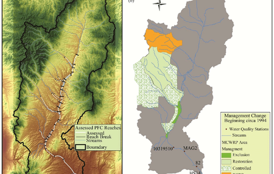
Stream and wetland riparian areas are able to sustain a state of resiliency based on the ecosystem’s ability to attain the functions of its ecological potential. This resiliency allows an area to provide and produce desired and valued water quality and aquatic habitat ecosystem services. Maintaining healthy aquatic and riparian habitats depends on “management” allowing for, or facilitating natural recovery of riparian functions. Altering grazing management practices in Maggie Creek lead to changes in riparian functionality, water quality, and aquatic habitat. Maggie Creek basin, historically renowned for its fishery, is one of only a few watersheds in Nevada capable of supporting Lahontan Cutthroat Trout (LCT) (Oncorhynchus clarkia ssp. Henshawi) meta-populations. Prior to 1993, the majority of Maggie Creek was grazed by cattle throughout the growing season. Decades of intensive grazing, water development, and road construction degraded aquatic and riparian habitats. By the early 1990’s, a majority of the Maggie Creek watershed was rated as nonfunctional or functional-at-risk condition with unstable banks, channel incision, loss of riparian vegetation, wide shallow channels, excessive erosion and deposition, reduced stream flows, and increased water temperatures. As mitigation for their 1993 South Operations Area Project mine dewatering, Newmont Mining Company, in cooperation with the Elko District Bureau of Land Management (BLM) and the Elko Land and Livestock Company, developed the Maggie Creek Watershed Restoration Project to enhance LCT habitat. The project was developed to enhance 82 miles of stream, 2000 acres of riparian habitat and 40,000 acres of upland watershed primarily through prescriptive livestock management. Beginning in 1994, grazing systems were implemented for portions of the perennial/intermittent streams. This greatly reduced the frequency and duration of hot season grazing on Maggie Creek and its tributaries. The objective of this paper is to compare 1994 and 2006 stream and wetland riparian assessments using proper functioning condition (PFC) protocol and water quality data.
An ecological function and services approach to total maximum daily load (TMDL) prioritization
Robert K. Hall, David Guiliano, Sherman Swanson, Michael J. Philbin, John Lin, Joan Aron, Robin J. Schafer & Daniel T. Heggem
Environmental Monitoring and Assessment volume 186, pages 2413–2433 (2014)
Abstract
Prioritizing total maximum daily load (TMDL) development starts by considering the scope and severity of water pollution and risks to public health and aquatic life. Methodology using quantitative assessments of in-stream water quality is appropriate and effective for point source (PS) dominated discharge, but less so in watersheds with mostly nonpoint source (NPS) related impairments. For NPSs, prioritization in TMDL development and implementation of associated best management practices should focus on restoration of ecosystem physical functions, including how restoration effectiveness depends on design, maintenance and placement within the watershed. To refine the approach to TMDL development, regulators and stakeholders must first ask if the watershed, or ecosystem, is at risk of losing riparian or other ecologically based physical attributes and processes. If so, the next step is an assessment of the spatial arrangement of functionality with a focus on the at-risk areas that could be lost, or could, with some help, regain functions. Evaluating stream and wetland riparian function has advantages over the traditional means of water quality and biological assessments for NPS TMDL development. Understanding how an ecosystem functions enables stakeholders and regulators to determine the severity of problem(s), identify source(s) of impairment, and predict and avoid a decline in water quality. The Upper Reese River, Nevada, provides an example of water quality impairment caused by NPS pollution. In this river basin, stream and wetland riparian proper functioning condition (PFC) protocol, water quality data, and remote sensing imagery were used to identify sediment sources, transport, distribution, and its impact on water quality and aquatic resources. This study found that assessments of ecological function could be used to generate leading (early) indicators of water quality degradation for targeting pollution control measures, while traditional in-stream water quality monitoring lagged in response to the deterioration in ecological functions.


